
A Bushfire Attack Level (BAL) is a means of measuring the severity of a building’s potential exposure to ember attack, radiant heat and direct flame contact. It’s measured in increments of radiant heat (expressed in kilowatts/m2).
A BAL is the basis for establishing the requirements for construction (under the Australian Standard AS 3959-2018 Construction of Buildings in Bushfire Prone Areas), to improve protection of building elements from bushfire attack.
Once assessed, your site/property/asset will be defined one of six BAL ratings:
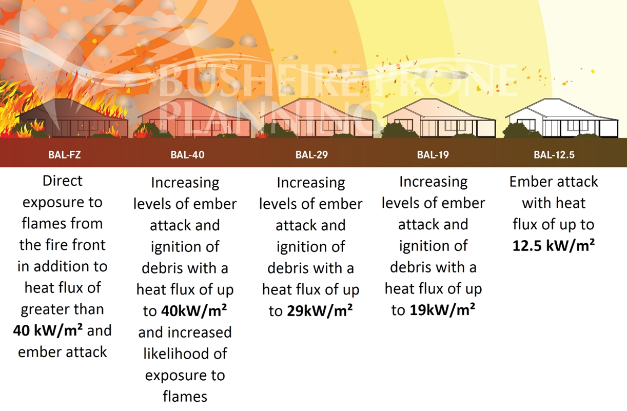
- BAL – Low: There is insufficient risk to warrant specific construction requirements.
- BAL – 12.5: Ember attack.
- BAL – 19: Increasing levels of ember attack and burning debris ignited by windborne embers, together with increasing heat flux.
- BAL – 29: Increasing levels of ember attack and burning debris ignited by windborne embers, together with increasing heat flux.
- BAL – 40: Increasing levels of ember attack and burning debris ignited by windborne embers, together with increasing heat flux and with the increased likelihood of exposure to flames.
- BAL – FZ: Direct exposure to flames from fire, in addition to heat flux and ember attack.
The image below shows the various BAL ratings and the radiant heat flux for each rating. The greater the distance from the fire the lower the heat flux and therefore the construction standard is lower.
Where your building is greater than 100m from any classified vegetation the BAL rating will be BAL–LOW and will not require any special construction requirements. Where there is a risk or potential that ember attack could affect your home we recommend that BAL – 12.5 is applied.
Bushfire Prone Planning will correctly identify your sites BAL (as per AS3959 – 2018) and can also help clients identify appropriate and effective means to achieve a ‘target BAL’.
Depending on the outcomes of your BAL assessment, building construction standards can be increased to meet the requirements of your assessed BAL. Alternatively, vegetation modification surrounding the allotment/dwelling can be undertaken to reduce the BAL and consequent exposure level during a bushfire.
A BAL not only helps identify bushfire risk, but also identifies specific construction standards required to improve the performance of buildings subjected to bushfire attack (construction standards listed in AS3959-2018).
Certain Local Governments may not approve a development or subdivision if your BAL is deemed ‘too high’ (eg. BAL-40 or BAL-FZ), so understanding your building or sites BAL is very important.
- Bushfire Management Plans (BMP’s) is an in-depth method to identify the extent of bushfire hazard to a development. They are far more involved and extensive than Bushfire Attack Levels (BAL’s) including factors such as; climate, topography, fuel loads, adjacent land use, offsite and onsite assets, water supply, emergency vehicle access, emergency escape routes, fire history and current fire risk.
- They also sets out short, medium and long term bushfire risk management strategies for a particular area.
- A BMP can be undertaken by an accredited Level 2 or Level 3 Bushfire Planning Practitioner.
Bush fire prone areas are areas identified to be subject to, or likely subject to, bushfire attack. It is recognized by the presence of, and proximity to, bush fire prone vegetation, and includes both the area containing the bush fire prone vegetation and a 100m buffer zone immediately surrounding it.
If a bush fire prone area partially covers a parcel of land, the entire parcel is treated as a bush fire prone area.
Visit the DFES Bush Fire Prone Areas map to learn more.
- It is our role to know whether your property is bushfire prone.
- We know exactly what legal requirements and planning processes govern your area. All our plans are tailored to fit the requirements of your Local Government, the Bush Fires Act (1954) and the WA Planning for Bushfire Risk Management Guidelines.
- The DFES Bushfire Prone Areas map is a useful tool to identify if you property is located within a bushfire prone area, however local government regulations also apply.
- If you do have preliminary questions you can always contact your Local Government to determine whether your property is located within a bushfire prone area and the approvals that are appropriate for your specific project.
A Building Protection Zone (BPZ), also known as an Asset Protection Zone (APZ), is a fuel-reduced area that surrounds a building or asset (in accordance with the Western Australian Planning for Bushfire Protection Guidelines). The BPZ assists in reducing fire intensity when a potential bush fire impacts on a building or asset.
A BPZ must meet the following criteria:
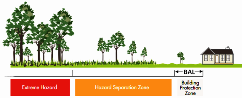
- A minimum of 20 meters width measured from any external wall of the building;
- Located within and external to the boundaries of the lot on which the building is located;
- Fuel load reduced to and maintained at 2 tonnes per hectare;
- Trees (crowns) at a minimum of 10 meters apart, and not overhanging the building;
- Trees also pruned to a maximum height of 2 meters tall;
- No tall shrubs or trees within 2 meters of a building (including windows);
- Fences or sheds must constructed using non-combustible materials (e.g. Colorbond, iron, brick or limestone);
- No shrubs or trees that contain dead material within the plant; and
- No tall shrubs arranged in clumps or planted close to buildings (i.e. within 3 meters).
In WA, all new building work is required to comply with the requirements of the Building Code of Australia (BCA). The BCA, amongst other things, provides specific construction requirements for building in designated bushfire prone areas.
The Australian Standard AS3959-2018 Construction of Buildings in Bushfire Prone Areas specifies the construction requirements for buildings in bushfire prone areas. It aims to improve a buildings resistance to bushfire attack from burning embers, radiant heat, flame contact and combinations of all three attack forms.
Construction requirements are determined by a buildings determined BAL. BAL methodology and BAL specific requirements are all listed within the AS3959-2018.
New bushfire land-use planning and development reforms aim to manage and reduce the risk of bushfire across the State.
The bushfire planning reforms outline the new planning and/or building processes for planning proposals, subdivision applications, and the development of new and other habitable buildings in bushfire prone areas.
The Western Australian bushfire planning reforms (2015) include the State Planning Policy 3.7 and the Guidelines for Planning in Bushfire Prone Areas and the Planning and Development (Local Planning Schemes) Amendment Regulations 2015.
New purpose of these reforms is to manage and reduce the risk of bushfires within Western Australia.
For more information, visit the Department of Planning website.
The Department of Fire and Emergency Services provide a useful tool that explains bush fire danger ratings and their implications.
https://www.dfes.wa.gov.au/hazard-information/bushfire/bushfire-prone-areas
Service Areas


 |